LIDAR – Lasers Rule for Remote Distance Measurement
Autonomous vehicles, military ranging, atmospheric sensing, and traffic monitoring are just some of the applications for this versatile technique.
February 17, 2022 by Coherent
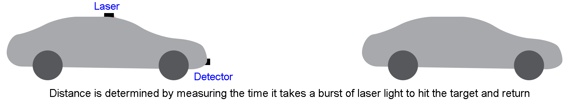
LIDAR, which stands for light detection and ranging, is a laser-based method for remotely measuring distance, speed, and many other quantities. The basic principle of LIDAR is actually quite easy to understand. A pulse of laser light is directed at an object, and the time it takes that pulse to reach the target and bounce back is measured. Since we know how fast light travels, that time delay tells us exactly how far away the object is.
Not surprisingly, the military has been using LIDAR since the early 1960s to measure the distance to targets. At first, there weren’t many other applications for this technique. But, over the years, engineers and scientists realized you could actually do much more with LIDAR. Let’s see what some of those are.
Laser mapping – from storms on Earth to mountains on Mars
LIDAR is used in a way similar to radar to map both stationary and moving objects. Here, the laser beam is swept across the object or region repeatedly until it has illuminated the entire area of interest. This way the whole shape of the object is determined.
But, because of the characteristics of laser light, LIDAR usually delivers much better resolution and precision than radar. In other words, it gives a much more accurate picture of object shape. Since this technique gives us the position, height, width, and depth of the target, scanning LIDAR is often called 3D scanning LIDAR or just 3D LIDAR.
LIDAR scanning/mapping applications are quite diverse. It’s used for mapping storms and the surfaces of planets (like Mars) from orbiting satellites. LIDAR also has huge potential use in autonomous vehicles and advanced driver assistance systems because it can deliver accurate information on the position of other cars and terrain features. Coherent supports the development of “eye-safe” lasers for automotive LIDAR applications with our extensive range of active and passive optical fibers and our tapered diode laser amplifiers.
Doppler LIDAR - getting wind of what’s ahead
In addition to size, shape, and position, LIDAR can also measure object speed. This is accomplished using Doppler LIDAR. This relies on the fact that when light is reflected by a moving object, there’s a slight change in frequency (color) of the return pulse. So measure the frequency shift, and you know the speed. The radar guns used by traffic cops rely on exactly the same principle.
One common application for Doppler LIDAR is for measuring wind speed near airports. It’s also used in high-performance racing yachts to identify the most favorable wind gusts.
When the target for Doppler LIDAR isn’t a single solid object, but rather a cloud of water vapor, the returned light doesn’t have a single frequency shift. It’s actually a band of frequencies, and the width and shape of that frequency band tells us how fast the molecules are moving in the cloud – in other words, the temperature.
Raman-LIDAR is looking up for atmospheric scientists
There’s an even more subtle effect that occurs when a laser pulse hits gas molecules. A very, very small number (as few as 1 in a billion!) of molecules will change the frequency of the reflected light through the so-called Raman effect.
Every molecule has a specific “fingerprint” of frequency shifts it produces, meaning that Raman-LIDAR can be used to identify specific chemicals, such as water, methane, and carbon dioxide. This allows a Raman-LIDAR system to be directed into the atmosphere for remote detection of “greenhouse gases.” This method can even provide the concentration of these various chemicals.
This technique has been exploited by a group of scientists from the Karlsruhe Institute of Technology (KIT, Garmisch Partenkirchen, Germany). They built a specialized Raman-LIDAR system using a powerful Coherent LEAP excimer laser that they modified specifically for their application. This system was placed in a research station near the summit of Mount Zugspitze, Germany’s highest (2964 m) peak. Using it, the group has measured water vapor at heights far past 20 km and made temperature measurements up to an incredible 80 km in the atmosphere. All without leaving the comfort of their research station.
LIDAR is a powerful and flexible technique, used in applications as diverse as meteorology, space exploration, automobiles, research, and defense. Coherent lasers, fibers, optical components and more deliver the combination of performance, reliability, and economy required to power many of these.
Related Resources